Afghanistan - The Center of Great Game
Geography
Afghanistan is a landlocked country located in South Central Asia, bordered by Pakistan to the south and east, Iran to the west,
Turkmenistan, Uzbekistan, and Tajikistan to the north, and China to the northeast. Its diverse geography includes
mountains, deserts, and fertile valleys, with the Hindu Kush mountain range running through the country.
Population
Afghanistan is made up of 421 districts and 34 provinces. The principal units of government are the provinces, which are further subdivided into districts. Administrative changes may result in a shift in the number of districts over time.
Kabul is the capital and largest city of Afghanistan, located in the eastern part of the country, and its situated in a narrow valley between the Hindu Kush mountain and the Kabul river.
Kabul elevation from the mean sea level is about 1800 meters making it one of the highest capitals in the world.
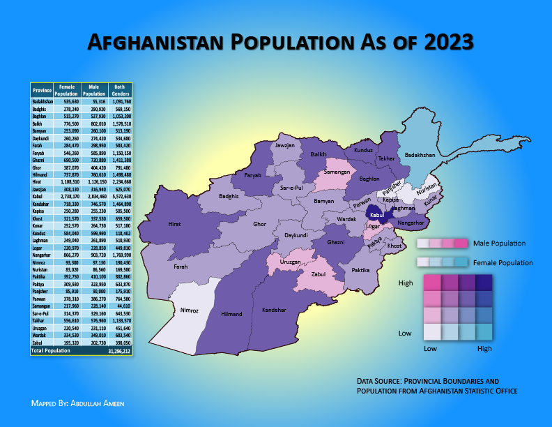
According to Worldometers, the current population of Afghanistan is 43,058,131 as of November, 2024. The below Bivariant choropleth map is made from another dataset that shows the total population and population by gender for each provice.
The Bivariant* Choropleth map and table give a detailed view of population distribution by gender across Afghanistan's provinces, with visual emphasis on areas with higher and lower populations. The information on this map can help understand population density and gender distribution in different parts of the country.

* A bivariant choropleth map is a type of map that uses color to represent two different variables across geographic areas, allowing the viewer to see how the two variables might be related in each location. In this example, the variables are female and male genders accross the country.
History
Ancient History - BCE (Before Common Era)
Early Civilization: Afghanistan's history dates back thousands of years. The current Afghanistan and neighboring Countries to Afghanistan was part of ancient cultures like the Indus Valley Civilization (3300–1300 BCE).Achaemenid Empire (6th–4th century BCE): Afghanistan became part of the Persian Empire under Cyrus the Great. Cyrus the Great, was the founder of the Persian Achaemenid Empire.
Alexander the Great (4th century BCE): Alexander Conquered the region and founded some cities like Kandahar (originally Alexandria Arachosia). Alexander the Great, was a king of the ancient Greek kingdom of Macedon, One of the world's military generals, who created a vast empire that stretched from Macedonia to Egypt and from Greece to part of India.
Bactrian (باختری) Kingdom & Buddhism (3rd century BCE–4th century CE): A major center for Greco-Buddhist culture and trade on the Silk Road. Bactriana (باختر), was an ancient Iranian civilization in Central Asia based in the area south of the Oxus River (modern Amu Darya) and north of Hindu Kush the mountains, an area within the north of modern Afghanistan. Buddhism was brought from northern India to Afghanistan during Bactrian civilization.
When did Islam arrive in Afghanistan
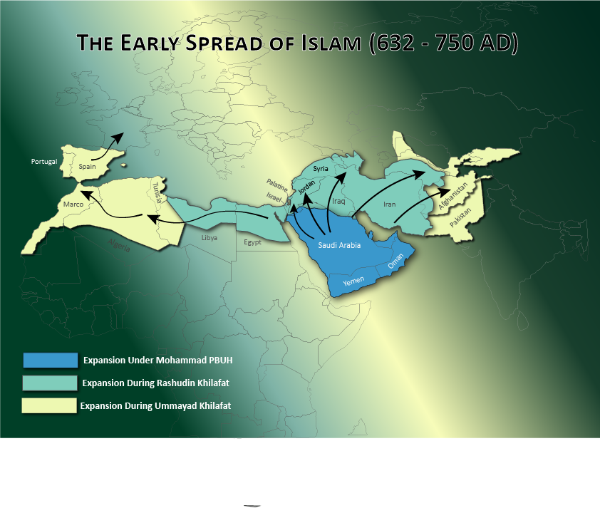
Islam arrived in Afghanistan during the 7th century CE as part of the Muslim expansion under the Rashidun Caliphate. The spread of Islam began shortly after the Battle of Nihawand in 642 CE, which marked the defeat of the Sassanian Empire by Muslim forces.
This victory opened the doors for Muslim armies to push further eastward into regions that are now part of modern-day Afghanistan.
At the time of death of Prophet Muhammad (PBH) in 632, Islam dominated the Hejaz (western Arabia).
Under the first two Khalifas, Abu Bakr and Umar, Islam expanded into Palestine and Mesopotamia, defeating the East Roman and Sāsānian empires, both weakened by internal struggles.
After the Battle of Yarmouk (636), the Muslims turned east, defeating the Sāsānians at the Battle of Qadisiya in November 636,
leading to the loss of Iraq to the Muslims.
